1. About this webpage
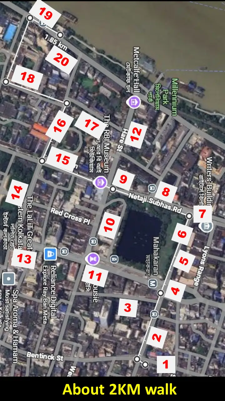
This webpage is a walking guide through the Dalhousie Square area. It would show the buildings that have vanished for new developments. About 2 kilometres (following the white lines on the image) walking would reveal some of the old heritage assets of the BBD Bag area.
Heritage sites are marked on the map with labels. Touching the corresponding number on the list below the map would open the window showing the earlier images of the area.
2. Dalhousie Sq. Introduction
Dalhousie Square was the seat of the British Raj till 1911. Even after the capital shifting, Kolkata remained a strong industrial hub till 1960, keeping the city centre in shape. Things started to deteriorate fast thereafter. Several important buildings have been demolished, as shown in the antique map below.
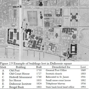
By 2004 and 2006, the World Monuments Watch listed the Square as one of the most endangered built heritage site in the world. Following watch-listing and local solicitation of interest groups, the government of West Bengal pledged to preserve the site; the municipality created its own list of landmarks, 55 of which were located in the Dalhousie Square Heritage Zone.
Many of the important buildings have already been demolished. However, since 2009, most of the important buildings have been protected from demolition but preservation of the old stock is still a major challenge.
Wish to see more?
1. Pre-english vestiges
English and Bengali historians both said the same story about naming the Lal Dighi. There was a Radha Krishna temple near it. Some says that the abeer used during holi made the pond water reddish. Even without such incident, the name could derive from Lord Krishna who was often referred as the Nandalal, son of Nanda or only as Lal. The nearby places have similar names like Lalbazaar, Radha Bazzar etc.
Dalhousie Square was the seat of the British. They built this area. In order to search for any vestige of the pre-English site has to look for the temple, which they hardly demolished even at the height of their power. The challenge is where the temple is in Dalhousie Square?
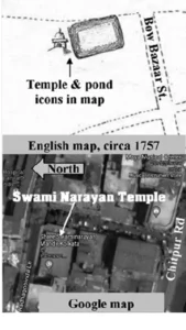
We searched old maps and found a temple in couple of maps as shown.
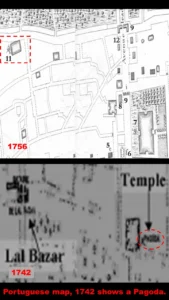
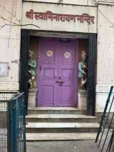
The red dotted square of the 1756 map showed a temple. The Portugeese map of 1742 also showed it. We found a plot where the temple does not exist but it is still a Vaisnab Math, presently managed by the Gujrati communities. This is the only sign of a pre-English site still existing. A blow up of the red dotted square is presented herein

A temple might move or lost but the deities shall most likely, be taken away by the Sebaits. The question is where are the deities? There are two contenders. The Kalighat temple Sebaits claim that the deities were moved to Radha Krishna temple in Kalighat. The Setts of BaraBazar claim that the deities are moved to their house temple in Posta.
The old map is superimposed on a Google map to locate the original temple. It has been found still to be a Vaisnab temple. Temples are usually constructed on debottar property. A Radha Krishna temple shall, therefore be always aVaisnab temple. Interestingly, the present use is by the Swaminarayana trust mostly managed by the Gujrati community in Kolkata. Swaminarayanas are also Vaishnabite. Therefore, the debottor covennant is still applicable to land. The name of the lane is still Radha Madhab Lane, carrying the legacy of the old temple.
2. Lal Bazaar
John Palmer (1767-1830) was one of the richest merchant of Kolkata. The Lal Baazar police station was built after demolition of his earier house.
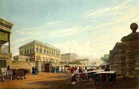
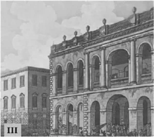
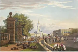
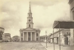
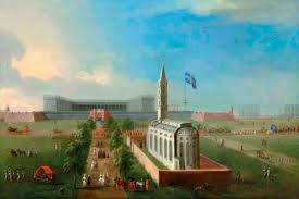
4. St. Andrews Church
The Old Court House built in 1727 was situated here before the St. Andrew's church. A painting of 1787 is presented.
The land was distrubuted for the St Andrew's, a Scottish church in 1818.
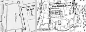
6. St. Anne's Church
St. Anne Church was the first church of Calcutta, consecrated in 1709. It was destroyed by Siraj's army in 1756.
The oil painting was decorative for the company office in London. The sketch is much humble as shownbelow.
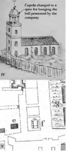
The church was plotted in a scaled military map in 1856 as shown above. The church foundation has been plotted in the Google map. An excavation would reveal the foundation which could be made open for public by covering it with epoxy sheet. Many such displays are made in the advanced economy.
7. Holwell Monument
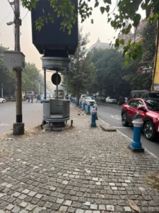
Present status of the traffic Island where Holwell Monument was existing
Wish to see additional images?
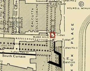
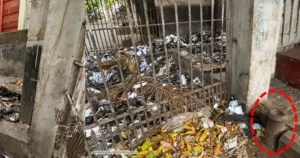
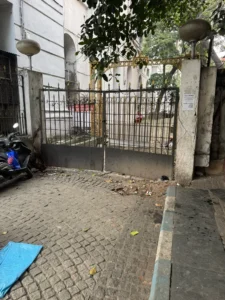
8. Black Hole Location
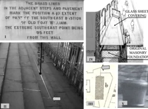
Black hole location marking has not been preserved. The 1901 marker by Lord Curzon is presented.
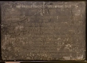
The exact location was marked with a discarded canon by Lord Curzon, but it has been removed by the state archeological department. They didn't know why the canon was left there.
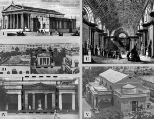
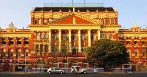
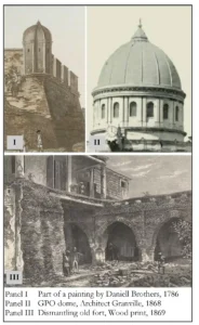
Old Fort & GPO
Old Fort William layout and bearing with the road.
The South East tower in old Fort was maintained in GPO architecture.
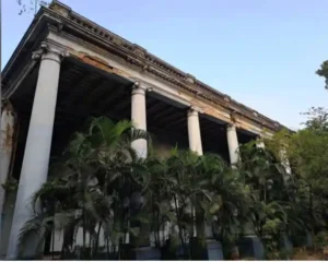
10. Dalhousie Club
The institute was demolished tomake room for the Telephone Bhavan